The National Geographic Okavango Wilderness Project (NGOWP) is a long-term conservation science initiative originally established as a partnership between the Wild Bird Trust and the National Geographic Society. Its mission is to explore, document, and support the protection of the Okavango River Basin—a vast and biodiverse ecosystem spanning Angola, Namibia, and Botswana.
The project is dedicated to understanding and preserving this critical landscape, which sustains the Okavango Delta, one of the largest freshwater wetlands in Southern Africa, and supports extraordinary biodiversity alongside the livelihoods of millions of people.
Through scientific research, exploration, and collaboration with local communities, NGOs, and governments, NGOWP works to support the long-term protection and sustainable management of this vital transboundary system.
The partnership focuses on the four most important conservation priorities on the African continent today: water security, carbon storage, wildlife corridors and biodiversity conservation.


The founding objective of the National Geographic Okavango Wilderness Project is to explore and survey the least-known and most inaccessible parts of the Okavango River Basin across Angola, Namibia, and Botswana.
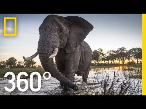
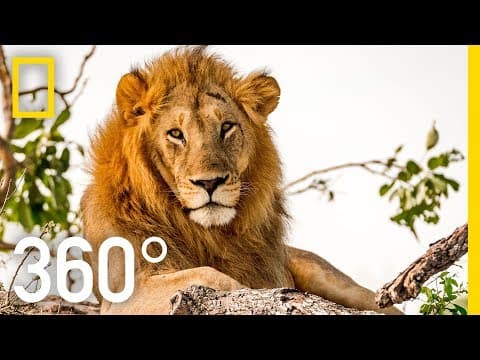
The Okavango Delta in northern Botswana is one of the largest freshwater wetlands in Southern Africa and supports exceptional biodiversity, including large populations of elephants, lions, leopards, wild dogs, buffalo, giraffes, hippos, and rhinos.
The source of the system lies in the Angolan Highlands Water Tower—known locally as Lisima Iya Mwono (“Source of Life”)—a vast elevated landscape of rivers, peatlands, lakes, and miombo woodlands. This region is the primary water source for the Okavango Delta and is fundamental to the health of the wider Okavango, Kwando, and Zambezi river systems.
Donate Today
Become a champion for change. Any donation will help us to conserve our incredible wildlife heritage.
hydrological monitoring project
Since 2015 the NGOWP has systematically explored the major rivers that sustain the Okavango delta namely the Cuito, Cuanavale, Cubango and Cuando.
The Hydrological Monitoring Programme (HMMP) is a core component of NGOWP’s scientific work, designed to track and understand the water systems that sustain the Okavango Basin.
The programme records water flow, water quality, and climate data at key monitoring points across the river system, including the Cuito, Cuanavale, Cubango, and Cuando rivers.
By generating long-term, standardised datasets, the HMMP provides critical insight into how water moves through the basin and how it is affected by climate variability and land-use change.
This information is essential for understanding the health of the Okavango-Zambezi Water Tower and supporting evidence-based conservation planning across Angola, Namibia, and Botswana.
the okavango experience
Since 2015 the NGOWP has systematically explored the major rivers that sustain the Okavango delta namely the Cuito, Cuanavale, Cubango and Cuando.
In 2018, filmmakers joined the National Geographic Okavango Wilderness Project team in Botswana during field expeditions along the Delta’s waterways. Using immersive 360-degree video and spatial audio technology, they documented life on and around the river system.
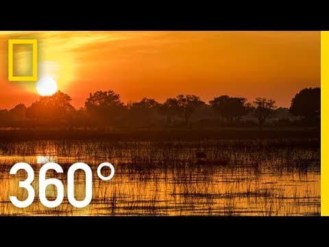
The resulting four-part series, The Okavango Experience, allows viewers to explore the Delta in an immersive format—from mokoro journeys through wildlife-rich channels to sunsets over ancient landscapes and close encounters with iconic species.


The experience brings audiences into the heart of the Delta, capturing elephants moving through floodplains, hippos in narrow channels, birdlife at dawn, and the unique atmosphere of one of the world’s most extraordinary ecosystems.
Okavango Explore is an interactive StoryMap that illustrates how rainfall in Angola’s highlands feeds the Okavango Delta and highlights the scientific research and conservation efforts underway across the basin. It provides an accessible platform for understanding the connections between water, ecosystems, and communities across Angola, Namibia, and Botswana, and showcases how ongoing research is helping to protect this globally significant landscape.
resources
Read about all the latest news, research and inspiring stories on The National Geographic Okavango Wilderness Project.
Kwando (2019) | Documentary | National Geographic Okavango Wilderness Project
Kwando (2019) tells the story of a young Angolan fisherman who joins a team of international scientists. The fisherman is haunted by his past as a child soldier and is uncertain about his future. The documentary explores the Okavango Basin is a natural water tower, composed of hundreds of streams that start in the Angolan plateau and provide trillions of litres of water to the famous rivers of the African continent. The Okavango Delta in northwestern Botswana, one of the last untouched wilderness regions in Africa, and its importance for both wildlife and the local economy. It is home to a rich biodiversity, including the world's largest population of elephants. The documentary also delves into the challenges of navigating the Kwando River, known for its floodplains and the potential presence of landmines left over from the civil war in Angola. The team of scientists and local guides conduct various surveys, including animal sightings, fish and reptile collection, and water quality tests. They aim to understand this unique and fragile ecosystem to help future generations. The documentary also touches on the impact of war on both humans and wildlife, as well as the importance of conservation efforts for the survival of this ecosystem.


Join our flock
Subscribe to our newsletter to receive exciting news about our projects.
We care about the protection of your data. Read our Privacy Policy.